By WILLIAM SHANNON
We stepped onto a path from the Appalachia trailhead just before 5:30 in the morning, with scattered birds chirping and wisps of fog creeping through the twilight.
My brother and I planned an early start because our aim was to complete what’s called a presidential traverse—summiting all eight peaks in the White Mountains that are named after presidents, including Mount Washington, which, at 6,288 feet in elevation, is the highest peak in the northeastern United States.
We were both excited to get into the woods—and maybe both a tad worried that we’d be above tree line when the thunder storms slated for late in the day rolled in. Our pace for the early half of the day was swift.
We slowed gradually a few hours in, as we climbed higher in elevation and partly since, as my brother said, we were “beating the hell out of book-time.”
A large yellow sign stopped us with the message, “The area ahead has the worst weather in America. Many have died there from exposure, even in the summer. Turn back NOW if the weather is bad.”
The low-lying fog continued to traipse through the foothills and the sun traced the course of flowing clouds with shadows on the trees below.
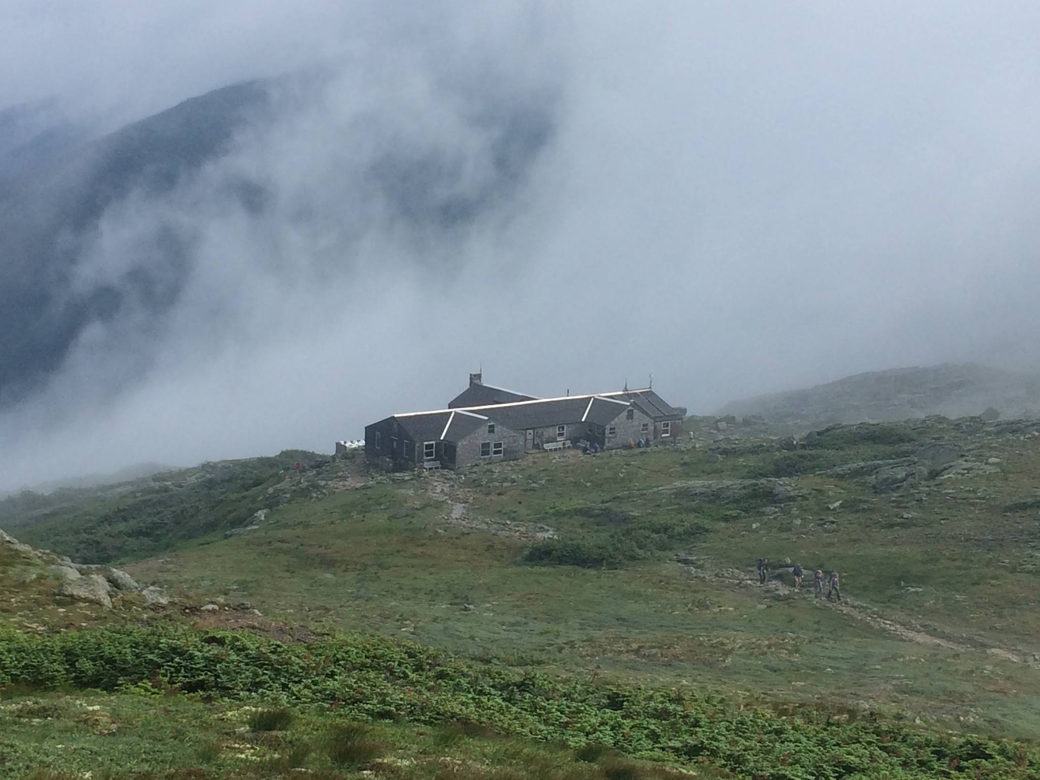
We approached the Madison Hut, one of several huts in these mountains where people can reserve a spot in bunkhouses and receive a hearty dinner, a dry place to sleep and a full breakfast the next morning before continuing to trek in the wilderness.
Passing the hut, we continued up the steep and rocky path marked by cairns to the summit of Mount Madison.
We spent a few minutes admiring the vistas of distant hills and the lakes they cradled.
A translucent morning haze blanketed the valleys.
As we back-tracked down from Mount Madison, I realized I was attempting my first hike in the Presidential Range with the perfect person. My brother, since an early age, could list all the U.S. presidents, forward or backward, and tell you about each one.
“Tell me a bit about Madison—I don’t know anything about him,” I said, our shoulders now turned to his peak.
He took copious and comprehensive notes on the drafting process of the Constitution, my brother said, and if not for his notes, we might not know a whole lot about how the process unfolded. He was also somewhat of a protege of Thomas Jefferson, and followed him to become the fourth president. He was a federalist early—a believer in a strong national government for the young country—but evolved later in his life to become more partial to Jefferson’s views on states’ rights.
My brother continued filling me in as we descended, back toward the Madsion Hut.
We stopped briefly to fill up on water at the hut and then climbed the Gulfside Trail to the peak of Mount Adams.
The presidentials were named roughly in order of the presidents, with the highest peak named after Washington; the second-highest peak named after Adams, and so on, except that Mount Monroe (named after the fifth president), turned out to be 22 feet higher than Madison, due to an early surveying error.
Once we arrived at the summit of Mount Adams, I dropped my backpack next to a sign pointing the way of converging trails.
While I transferred water from my large water bottle to my small bottle, my eyes flowed to a small glass bottle with a white substance corked in.
The bottle was tucked away, barely visible, between the rocks a few feet from where I kneeled.
I finished pouring the water and put the large bottle back into my pack. My curiosity guided my hand down into the rocks.
Once I held the glass bottle, I saw a small rectangular sticker label.
Written in marker on the white label was a man’s name and, “11/4/54—1/25/15.”
“He must’ve loved this mountain,” Tom said.
I agreed.
I placed it back, a little deeper, into the crack between the rocks.
We trekked on toward Mount Jefferson.
Our approach to the summit of Jefferson a couple hours later was steep and tiring and, by that time, all we could see, besides the rock beneath our feet and ahead of us, was white. Thick fog and mist, sprayed by an increasing wind, surrounded us. But we climbed the final pile of large rocks at Jefferson’s summit for good measure.
Weather conditions change quickly in the presidentials. Thunder storms pound with intensity and hurricane-force winds aren’t uncommon. This unpredictability is one of the main reasons they make for a good training range for climbers preparing to climb some the world’s most dangerous peaks.
The fog and wind came and went a few times that afternoon. My brother and I chugged along for the few miles down from some of Jefferson's elevation and up toward Mount Washington. Long views appeared from the clearing fog as we passed Mount Clay.
Washington gets all the glory in that it’s the one peak in the presidentials that has a road able to carry cars and tourists. At the top, there’s a visitors center, a museum and a food court. Mount Washington also has a cog railway that takes passengers up another side of the mountain.
We walked near the rail for a while during our slow-climbing approach.
The train whistle blew and the old-fashioned cars inched up the steep track with such struggle that I said, “I think we might beat it.”
A thick fog and heavy winds picked up and it rained a bit on us as we climbed the final stretch to Mount Washington’s summit.
This was a day when, a few miles away and down from the mountain, people would’ve been hot outside in shorts and t-shirt.
But up here it felt like winter.
We warmed up in the visitors center and I ordered a bowl of broccoli and cheese soup that tasted better than most food ever tastes.
We perused the museum. Mount Washington is known for logging the world’s highest wind speed ever observed—231 miles per hour, recorded in April 1934.
Moving on, we joined the Crawford Path and headed toward our stay for the night, the Lakes of the Clouds Hut.
An hour or two later, we reached the hut, though visibility was so low, we couldn’t see the building until we were right in front of it.
We checked in and put our bags in our bunks.
Five bunks, three-high.
Fifteen people in our room, which was one of four in the hut, peopled at full capacity.
The huts in the White Mountains are run by groups of young interns.
Not long after we arrived, my brother and I sat down at a long table for dinner, which the interns serve family style.
As we started eating, a man across the table told my brother and I and others around us to read a book called Not Without Peril, about deaths and misadventures in the White Mountains.
“It's always because they leave too late,” he said.
“This one family, two elderly people and a German exchange student, they leave too late, and the shit hits the fan. Like this," he said, pointing to rain and thunder outside and the waterfall of rain now pouring off a valley in the hut's roof.
The elderly man in that story doesn’t make it.
Another group, some other year, the man said, "They leave too late. The shit hits the fan," and one of that group too is taken by the mountains.
The next day we got an early start, right after breakfast at the hut, to summit Mount Monroe, which was steep but not far from our start.
Two guys reached Monroe’s summit just before we did.
One of them put on a white wig meant to mimic the hair style of our founding fathers and the other took a picture. “We’re doing this at every peak,” the guy putting on the wig said. “How do I look?”
“You look just like James Monroe,” my brother quipped.
On the way down from the summit, onward toward Franklin and Eisenhower, the morning chill eased and the sky cleared up so that we could see the valleys below.
A hiker’s high began to kick in.
Franklin was our extra peak—we didn’t technically have to trek that summit to complete a presidential traverse, but it was on our way to Ike.
We got a beautiful view from Eisenhower’s peak and spent a little time at the summit.
The day wore on and we summited Pierce. My brother filled me in on how Franklin Pierce was one of the pre-Civil War presidents who kept kicking the can down the road, missing probable opportunities to avoid the eventual war that killed more than a half-million Americans.
The path's grade eased.
We made good time all of the second day and approached civilization while still in the mid-afternoon, having summited nine peaks and hiked more than twenty miles over two days.
In the final stretch, my brother and I launched into a past-time of ours which is to debate all sorts of political issues in rapid succession, each playing devil’s advocate to the other and stirring what we know from experience can be stirred in the other.
I was attempting to make some really good point, when—my focus on footing long-forgotten—I took a heavy and thoughtless step onto a wooden tie bridging a creek.
The wood was slick from the previous day’s rains and my foot slipped off, sending the front end of my body toward the rocks a few feet below.
I caught my fall with my right hand and earned a few cuts to my thumb, but recovered and crossed the bridge in a couple seconds, returning to the point I was trying to make, but with less credence now.
***
Correction: An earlier version of this story accused James Monroe of being a can-kicking president leading up the Civil War; Franklin Pierce was the can-kicker.